
During my “2014 Winter SoCal Adventure,” I took a leisurely winter solstice kayak tour in 75°F southern California sunshine wearing sandals and a Santa hat. Ten days later, at home in cloud–shrouded southern Utah, it is nearly 50°F colder and I am wearing sweatpants and two pairs of socks. A winter Pacific storm is blustering its way across the western U.S., so it looks like I will be trading that kayak and sandals for some cross-country skis and insulated boots.
 |
| Feet on the Salton Sea – Winter Solstice 2014 |
It was billed as my “2014 Winter SoCal Adventure,” and I had been planning it since last spring. I would drive south for a week of urban camping in John and Cathy’s guest room, bird watch in lagoons, visit a museum, admire architecture, splosh around in tide pools and look for anemones to tickle, reconnect with Jo whom I have not seen in 30 years, be treated to dinner, leave the city, kayak on an inland sea, live a cushy condo life for five days, become familiar with the romance and sex life of dates, hike to desert oases, and spend Christmas Day bird watching once again. By the time it was all over I would have been gone for ten days, put away some serious fermented grape beverage, added 1,420 miles to my car’s odometer, and experienced the best vacation I have had in years while wearing a custom–made Santa Claus hat.
 |
| Two poinsettia earrings hang from my "jade plant cuttings in plastic cup" Christmas tree |
 |
| Taking Santa’s new green sleigh for a spin on the Salton Sea! |
I have located my little buddies here in southwest Utah! Well, I have not located them, exactly, but I have found clear evidence of their existence. Now it is just a matter of time before I catch the little rascals in action. And just who do you think these little rascals might be, industriously re–engineering their short stretch of the Santa Clara River?
 |
| Santa Clara River – more here than meets the eye! |
I went for a walkabout yesterday, two days after eating my way into a holiday food coma. That spiral cut ham–scalloped potatoes–pecan and cranberry dressing–vegetable medley–cranberry sauce–two pieces of pie–champagne and wine Thanksgiving dinner needed to be dealt with. So after nibbling on some leftover ham and forking my way across a hefty slice of breakfast pumpkin pie, I headed over to the Santa Clara Reserve to spend a few hours with friends, hiking and socializing in the great southern Utah outdoors.
 |
| I have enjoyed hikes with these guys for several decades |
Thanksgiving") |
| Gambel’s Quail (Callipepla gambelii |
How many footsteps are in a mile? If I had a nickel for every step I have taken getting into and out of the geyser basins of Yellowstone over the past four summers, I would be a wealthy individual. Include the eighteen round trip miles involved in accessing Shoshone geyser basin and I could retire comfortably right now. I would spend my golden years driving across the geology of the continent while towing the glamping camper of my dreams.
 |
| On the way to Shoshone geyser basin, hiking buddy Brian (aka "Tater") poses and points. |
The blistering heat has dissipated. The jostling summer crowds have disappeared from the trails. Shuttle buses still whoosh quietly up and down the main canyon, but only on the weekends. The sun casts its lengthening shadows on the towering cliffs of Navajo Sandstone. There is a definite chill in the air. This is Zion National Park in November, and it is a perfect time for a bicycle ride.
 |
| View from the handlebars |
When I was hired as a seasonal interpretive ranger at Yellowstone back in May of 2011, I knew few details about our first national park except that most of it is in northwestern Wyoming, it encompasses a ginormously snoozing yet still active volcano, and its yearly visitation numbers average somewhere in the bazillions. Fortunately, I quickly discovered that there is much more to Yellowstone than simply geysers and tour buses. There are also mountains, and many of them were here long before the volcano showed up. Furthermore, at least one particular range happened to be in the way of at least two of Yellowstone’s ginormous explosions. This range is the Red Mountains and it has its own peculiar personality.
 |
| View of Red Mountains across Riddle Lake, Yellowstone National Park |
There are certainly many extraordinary natural features to see in Yellowstone National Park, but I will bet there is one hillside in particular that might not have caught your eye. In fact, you could have driven right by this seemingly innocent slope on the road between Madison Junction and West Yellowstone without even giving it a second thought. After all, it looks just like any old slumping, eroding hillside.
 |
| Not just any old hillside |
This past weekend I found myself at loose ends. I am the proud owner of a new pair of birdwatching binoculars but had become weary of looking at flocks of house finches from my backyard patio perch. I wanted to go on a hike, but not one that was too strenuous or that involved packing much more than a bottle of water and an apple. With these simple criteria in mind, I decided to drive up to the Kolob Plateau area of Zion National Park and have a look around. It has been years since I’ve been up there and I was overdue for a visit.
 |
| Getting to Kolob Reservoir involves weaving in and out of a corner of Zion |
It was a crisp October morning as we zipped up Cedar Mountain in our three–car caravan, bound for an eight–mile hike around Navajo Lake and along the Virgin River rim trail. Interspersed with the grayed skeletal remains of Engelmann spruce (victims of an endemic beetle population and a dubious forest management policy of the past century), the aspen leaves blazed their burnt red–orange and golden yellow brilliance against a cloudless sapphire sky. As we cruised I noticed orange–vested people near the side of the road, parked in camp chairs and peering through binoculars across the meadows. A suspicious little voice inside my head told me they were probably not just admiring the leaves.

Two Ocean Lake is a gorgeous place for a hike. Tucked into a northeastern corner of Grand Teton National Park, it is a relic of the last ice age. During late spring and into summer, wildflowers are colorful and profuse, splashed across hillsides like an impressionist’s dream.
 |
| Trail along Two Ocean Lake to Grand View Point |
In the low desert of southern Utah these days, when mid–September temperatures not only approach triple digits but also have the audacity to linger there, it is time to head to the high country for a hike along the redrock near Cedar Breaks National Monument.

The summer begins, as it often does, with a hike. The summer ends, as it often does, with another hike. Looking back, I realize that two unique Wasatch Mountain trails have become the bookends of my summer.
 |
| American Fork Canyon in the southern Wasatch Range |
One day last week I found myself feeling kind of punky. I woke up a bit dizzy, and found that my blood pressure was higher than it usually is. For that reason, I decided to take a sick day. Unknown to me, though, while I was laying about in my government housing unit worrying about my blood pressure, I missed meeting Mary and Brad.
When I returned to work the next day, my blood pressure was back to normal but I was still feeling a bit out of sorts. As soon as I walked in the door, another ranger said that there was a message for me taped to the bulletin board. Two people had come to the visitor center the previous day, and asked for me, and they had left this note.

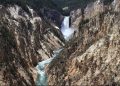
A smoky haze filled the skies, drifting across Yellowstone from forest fires burning to the west of us. I did not bring binoculars, nor did I bring my bigger “good” camera. The idea was to carry as little weight as possible, down into and up out of Seven Mile Hole.
 |
| Grand Canyon of the Yellowstone River |
I was up and out early the other morning, ready to spend a few quiet hours roving West Thumb geyser basin on Yellowstone Lake. At just past eight o’clock, I knew I would have the place pretty much to myself.
 |
| Boardwalk at West Thumb geyser basin on Yellowstone Lake |
As a summer seasonal park ranger in Yellowstone, I get asked a lot of questions, such as Where is the best place to take pictures?
My answer?
Pretty much anywhere you look.
 |
|||
| Early morning along West Thumb of Yellowstone Lake. Red Mountains in distance. |
Have you ever felt like going for a bicycle ride on a paved mountain path? I know just how you feel.

Just up the road a piece from Grant Village, along the shores of the West Thumb of Yellowstone Lake, there lies a gravel bar that is perhaps a mile or so long. When folks these days learn that its name is the “Hard Road to Travel,” they often wonder if it had been constructed as a road. They inquire, Who would build a road out there in the lake? Why would anyone do that?
 |
| Hard Road to Travel |
Before leaving Yellowstone last September, I walked around West Thumb geyser basin to snap some photos of the thermal features. At the time, these three adjacent thermal pools along the middle boardwalk had been full to the rim, crystal clear, and steaming. It looked like they could remain that way forever. I wanted to see whether any thermal features might change over the winter, though, and what surprises might await my return in the spring.
 |
| Blue Funnel Spring – September 2013 |
My original plan was to spend a few mid–May days at Antelope Island state park in the Great Salt Lake and hike Frary Peak, the highest peak on the biggest island in the largest saltwater lake in the western hemisphere. However, cold windy weather and a waffling state of mind led me to a change of plans. This change turned out to be fortuitous, since I would have most likely been eaten alive by Antelope Island’s famous biting gnats. Also, I might have missed this jaw–dropping Z fold in Ogden Canyon.
 |
| See the Z across the canyon! |
This was all Jerry’s idea. He wanted to go out to the Beaver Dam Mountains and look at the cool metamorphic rocks. There is a canyon on the other side of the mountains, he said. Why don’t we go check it out? Now, Jerry is a geologist but he is also a paleontologist, one of those peculiar people who studies dead things in mud. He claims metamorphic petrology sets his head to spinning. I only have an undergraduate degree in geology but I completed three years worth of field research in these rocks and did my senior project on them (you can read about some of that here!). He figured I could help him recognize a few things and so I said I would do my best to enlighten him.
 |
| Jerry becomes ONE with the metamorphic rocks |
Fossilization has been on my mind for several reasons, not the least of which is my having recently located a 270–ish million year old ammonite (read about the adventure here).
 |
| Permian limestones – where fossils are found |
Not too long ago a friend emailed me an intriguing image.
What’s this? He inquired.
Well, jeez, I replied. That’s an ammonite! Where in the world did you find that?
 |
|||
| An ammonite from NW Arizona |
Whoa! Has it really been since the end of February that I last posted anything? Time sure has its way of slipping quickly past us, doesn’t it? Happily, though, I have been out and about, geologizing myself and my friends into a fiendish frenzy while finding fascinating stuff. It has just taken me a while to write anything up.
 |
| Ben and Cindy, in a place unofficially named "Garnet Hill" |
There is a way to visit Yellowstone and have the place pretty much to yourself.

During the long cold months of a northwestern Wyoming winter, roads inside Yellowstone are only groomed for over–snow vehicles. There is the occasional skier who manages to ski the entire 35 miles between West Yellowstone and Old Faithful (in one direction or the other), but I definitely do not fit into that category of altitude–crazed athlete. I have enough to do just staying upright on the bunny slope (there will be more on this later).
 |
| The Bombardier and a line of snowmobiles stop for wildlife along the Park road |
If you’ve ever been to Yellowstone during the summer, you know what I’m talking about. Massive crowds! Tortuous traffic! Mosquitoes the size of tour buses! And don’t forget all those blasé bison, blocking traffic and generating more crowds just because they can!
Want some advice?
 |
| Follow the ski tracks in the Upper Geyser Basin for a trail less traveled |
In my previous post of Monday, January 6th I wrote about searching out the Liesegangen banding in the Navajo Sandstone of southern Utah. Walking around near Yant Flat outside St. George we found it easy to become mesmerized by the rocks as the afternoon sun slipped slowly behind the hills.
 |
| Mr. Ben investigates some purple banding |
An interesting feature of the Navajo Sandstone is the presence of Liesegangen banding, those ribbons of rustiness that swirl and whirl so dramatically across often vast expanses of rock.
 |
| Mr. Ben, Liesegangen banding, and the Navajo Sandstone |
 |
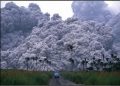
| Christmas Eve day 2013, Zion National Park |
