In my previous post, I wrote a bit about the wonders of Snow Canyon State Park here in southern Utah. Mainly I focused on the eye-catching contrast between the white and red Navajo Sandstone. However, I also referred briefly to the “Black basalt boulders, jagged relicts of relatively recent lava flows extruded from higher elevations, [that] cascade down through joints and fractures in the rounded multi-hued Sandstone.” I soon started pondering the history of these jagged relicts. Where did they come from? How old are they?
 |
|
| Qbl caps Navajo Sandstone;Pine Valley Mtn beyond;Highway18 on left |
These volcanic rocks are simply too intriguing to gloss over! Consequently, I again pored over Geology of Utah’s Parks and Monuments to unearth some straightforward answers. Map symbols for the lava flows are given in parentheses following the name. “Ma” following the date of the flow indicates millions of years.
Three basaltic lava flows in the park form steps down to the west (towards and into Snow Canyon) with decreasing age. These Quaternary flows include (from oldest to youngest) the Lava Ridge flow(Qbl), Snow Canyon Overlook flow(Qbso), and Santa Clara flow(Qbs/Qbsc) .
The Middleton lobe of the Lava Ridge flow (Qbl) has been dated at 1.41 ± 0.01 Ma, making Lava Ridge flow the oldest volcanic unit in the park. This flow erupted from heavily weathered cinder cones on Lava Ridge, about one mile east of the park; the flow caps the ridge at ≈ 4600 ft (1403 m) elevation.
 |
| Qbl caps Navajo Sandstone; Snow-covered Pine-Valley Mtn beyond |
 |
| Qbl pours off Navajo Sandstone from ridge east of Snow Canyon SP |
The Snow Canyon Overlook flow (Qbso) is the next youngest and has been dated at 1.16 ± 0.03 Ma. It probably originated 5-10 miles (8-16 km) to the east along the flanks of Pine Valley Mountain.
 |
|
| View west across Snow Canyon; Qbso forms cliffs; Qbs/Qbsc in canyon floor |
 |
| View west across Snow Canyon; note smooth, ropey pahoehoe lava in Qbso cliff on lower right |
Unlike the two older flows, there is no radiometric date for the youngest Santa Clara flow (Qbs/Qbsc). However, human skeletal remains along with an atlatl (probably manufactured in late Archaic to Basketmaker II times ≈ 1500-2500 years ago) were found inside a lave tube cave. The flow must be old enough to allow time for weathering and collapse of the roof of the lava tube to occur. With this and other evidence, the flow has been given an age of ≈ 10,000-20,000 years
.
 |
| Qbs/Qbsc followed break in Navajo Sandstone down from the right (highway 18 route) |
 |
| Qbs/Qbsc near north entrance to Snow Canyon SP |
The youngest Santa Clara flow(Qbs/Qbsc) fills the bottom of Snow Canyon, following the drainage level near 3400 ft (1037 m) elevation.
 |
| Qbs/Qbsc in floor of Snow Canyon (note park road); Qbso cliffs on right |
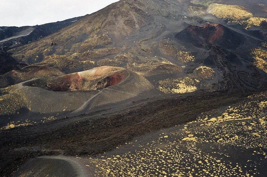
Vents at the base of two extinct cinder cones in the northeast part of the park have been found to be the sources of this flow. The cinder cones’ symmetry has been preserved since they were formed near the final phase of the eruption cycle. If the cinder cones had formed early in the eruption they would have been blown to smithereens by any later flow from the vents.
 |
| Highway 18 cinder cone in north corner of Park; one source of youngest Qbs/Qbsc |
 |
| Qbs/Qbsc cinder cone to left; Pine Valley Mtns beyond;base of other cone on right |
One more very intriguing feature related to the basalts that I have finally started to wrap my mind around is the “inverted valley.” These features are all over the place in southern Utah but up until the other day I could not quite figure them out.
 |
| Drainage between Qbl and Navajo Sandstone – incipient inverted valley? |
 |
| Incipient inverted valley? |
Here is the gist of inverted valleys, as best as I have worked them out in my head (since there is no definition to quote from my Glossary of Geology). Molten lava that once flowed across an undulating landscape hardened into basalt, which is more resistant to weathering and erosion than the landscape across which it flowed. As the underlying, less resistant rock (in this case, the Navajo Sandstone) weathered away, it left the basalt in place as a “cap” on a mesa. Over time, downcutting by streams along the sides of the resistant basalt and Sandstone created the inverted valleys.
Check out what the Utah Geological Survey has to say about inverted topography here. I was pretty much on the mark but they say it so much better than I do!
 |
| I am sure I know what I think this is. |
According to Higgins (2000), there are several places in the park to view inverted topography. To me, the weathering pattern shown in these last three images of the basalt (dark-colored rock) and Navajo Sandstone (light-colored rock) looks like the beginnings of an inverted valley.